The IJC has been directing dam operations to control water levels in Namakan and Rainy Lake since 1949, and one thing has become clear over the years: It’s difficult to come up with water level targets that are optimal for everybody. Adjustments to those targets bring up a variety of questions: How are fish like northern pike and walleye doing? How is wild rice production? What about the resort industry?
Since 2015, the International Rainy and Namakan Lakes Rule Curve Study Board has been investigating the benefits and drawbacks of the existing regulations and considering options for improvements, with help from a number of scientific studies and public meetings.
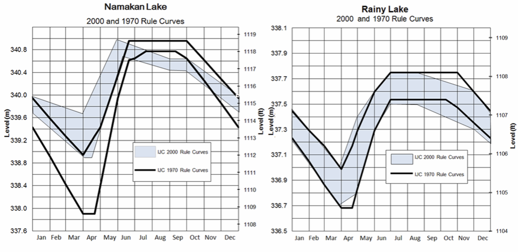
The board and IJC do this using rule curves, which are essentially a range of water level targets that dam operators should try to maintain throughout the year. The rule curves were last adjusted in 2000 when, following extensive IJC studies, it was decided to modify them from the previous rule curves set in 1970.
The 2000 rule curves set out to increase water levels on Namakan Lake in the spring and improve ecological conditions, navigation and tourism business during that season. Both lakes also saw rule curve adjustments in the summer and autumn to provide a more natural draw-down to winter water levels. When setting the 2000 rule curves, the IJC planned to review the changes in 15 years to evaluate how well they worked and if additional adjustments would be necessary.
To make that determination, the study board gathered preliminary information from 39 studies on the Namakan Lakes, Rainy Lake and Rainy River to determine how the 2000 curves have impacted wildlife such as muskrats, northern pike, walleye and sturgeon; hydroelectric power from the dams; vegetation such as wild rice; and economic factors like resort operations and the flooding of shoreline property.
Among its draft findings, the studies found that northern pike spawning and nursery habitats have improved in both lakes, as has walleye spawning habitat in Namakan. Invasive cattails have become more prolific in Rainy Lake but are almost the same as before in Namakan. Muskrats – which eat the cattails – are slightly more abundant in Namakan, but overall not much more than they were under the previous rule curves. Wetland vegetation has improved on Namakan while remaining about the same on Rainy, with wild rice production on both lakes largely unchanged under the new curves. Peak water levels are slightly higher on both lakes in high inflow years since 2000; studies suggest that is due to wetter years rather than the rule curves. The resort industry has improved substantially on the Namakan Lakes chain, as more customers can get their boats on the water earlier in the spring.
The study board also held six public meetings from July 26-28 in Minnesota and Ontario: at Crane Lake, Rainy River Community College in International Falls and Kabetogama Lake in the United States; and Rainy River, the Kay-Nah-Chi-Wah-Nung Interpretive Centre in Stratton and the Nigigoonsiminikaaning First Nation meeting hall in Canada. The study board also met with several groups over those days, including two advisory organizations - the Adaptive Rule Curve Group and the Rule Curve Public Advisory Group – as well as the Mitaanjigamiing First Nation. These meetings were focused on getting input from the people who live and work around the watershed and know about the impacts of these rule curves firsthand.

An estimated 75 people attended the public meetings, and provided a variety of ideas, opinions and information for the study board to consider. Kabegotama Lake residents and resort owners largely approved of the 2000 rule curve changes for their lake, as the higher water in the early spring has improved boat access for resort customers. Attendees there – and at other public meetings - also understood that the flooding in 2014 would have happened regardless of rule curves, as modeling showed that the 1970 rule curve would have reduced it by a minimal amount at best. And attendees at the Crane Lake meeting largely agreed that the higher water levels were preferable to the 1970 rule curve for getting boats out onto the water in their area. A few people suggested that anecdotally, the muskrat population seems to be improving. Both lakes are part of the Namakan chain.
At the International Falls meeting, the public discussed the possibility of adjusting the rule curves each year based on weather conditions and expectations, and discussed concerns generally about high water on Rainy Lake and pressures put on Rainy River and other downstream areas with fluctuating water based on the dam owners’ needs. Others suggested changing the curves so power companies don’t need to focus on keeping levels in the middle portion of the rule curve band. At Rainy River, residents stressed the importance of communicating river changes, and at Nigigoonsiminikaaning there was a discussion on how traditional ecological knowledge could be incorporated into lake regulation.

Though the International Dam on the Rainy River can help relieve the pressure in instances of heavy rains, the geographic structure of Rainy River includes choke points that limit just how much water can get out of the lake. When a storm is heavy enough, those choke points can lead to flooding even with all the dam gates open.
The final recommendations will be brought to the IJC in spring 2017, at which point the IJC will hold public hearings if it decides to make significant changes.

Kevin Bunch is a writer-communications specialist at the IJC’s US Section office in Washington, D.C.
Subscribe to our Newsletter!