Transboundary Waters
On this page you will find a listing of all the transboundary (those which cross) and boundary (those that form) waters along the Canada-U.S. border with a summary of IJC activities.
The following maps depict the key transboundary basins shared between Canada and the US. Wherever applicable, links to webpages of active IJC boards working in these watersheds are also included. Note that the Health Professionals Advisory Board does not appear under any watersheds because its work is not tied to any one specific watershed.

Yukon - Alaska - British Columbia Region
The longest river in Yukon and Alaska with a watershed that stretches as far south as British Columbia, the 3,190 km (1,980 mile) long Yukon River is a vital watercourse for indigenous communities, settlers, and industry. The river is among the most valuable salmon spawning habitat in its region and historically has been a major source of drinking water, though today faces water quality challenges and a reduced salmon run. Although governments have not issued any Orders or References to the Commission related to the Yukon watershed the IJC has undertaken some work related to its air quality responsibilities along the entire Canada-US boundary that included the region.

Skagit River
The Skagit River flows 241 km (150 miles) from British Columbia into Washington state before draining into the north end of Puget Sound. The river is largely free-flowing – save for a trio of dams that provide power to the city of Seattle – and features healthy populations of salmon, bald eagles, and snow geese. Ross Lake, formed by the Ross Dam, extends into British Columbia. Although the IJC does not have any Orders or References active on the Skagit River at this time, in 1984 it brokered an agreement for a "paper dam" giving the City of Seattle access to power from British Columbia at costs similar to the financing an increase in height for the Ross Dam which would have flooded 2,000 hectares of land in BC

Columbia River
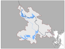
The Columbia River runs through British Columbia down into the states of Washington and Oregon, but its watershed spreads even beyond that into the boundary states of Idaho and Montana. The river and its tributaries are a major source of hydropower for the region, and the IJC’s Orders and References are specific to water level management due to these dams. The 2000 km river (1,243 miles) is also subject to the Columbia River Treaty between the Canadian and US governments, which are currently in the process of updating it. The river was also historically known for its fish runs, though the hydropower dams have introduced some barriers to ecologically and culturally important species such as salmon.
Boards
- International Columbia River Board of Control
- International Kootenay Lake Board of Control
- International OsoyoosLake Board of Control
St. Mary and Milk Rivers
The North Milk and Milk Rivers originate in the foothills of the eastern slopes of the Rocky Mountains in Montana and flow northeasterly across the international boundary into Alberta. Downstream from the confluence of the North Milk and Milk Rivers, the Milk River flows eastward and roughly parallels the international boundary for about 120 river kilometres (70 miles) and then flows southeastward before it re-crosses the International Boundary into Montana and eventually empties into the Missouri River. The river flow is dependent on spring snowmelt and rainfall in the foothills and is thus less regular and dependable than the St. Mary River as a source of water. The United States St. Mary Canal was constructed in 1917 and is used to divert water through a series of syphons from the St. Mary River to the North Milk River for use in the lower Milk River valley in Montana. The IJC provides direction for the measurement and apportionment of water that crosses the international boundary in the St. Mary and Milk River basins, in accordance with the Boundary Waters Treaty of 1909 and the IJC Order of 1921.
Board

Poplar River
Rising in the province of Saskatchewan and flowing 269 km (167 miles) into the state of Montana as a tributary to the Missouri River, the Poplar River has been subject to IJC references and Orders historically, though there are none at the moment. The apportionment of water from the river is overseen by the Poplar River Bilateral Monitoring Committee, formed by governments following a recommendation by the IJC. The committee also monitors water quality objectives for the river.

Souris River
The winding Souris River crosses the Canada-US boundary in two places, flowing from Saskatchewan to North Dakota before turning north into Manitoba. The 700 km (435 mile) long river is home to a variety of fish species, and runs through a variety of cities and towns, such as Minot, North Dakota, and Weyburn, Saskatchewan, where it provides a water source. The soil in the Souris River basin is ripe for agriculture, and waters from the river are apportioned according to an IJC Order, which created the International Souris River Board. The board also monitors water quality in the river.
Board and Study Board

Red River
Forming the boundary between the states of North Dakota and Minnesota, the Red River flows north into Manitoba before entering Lake Winnipeg. Situated in the fertile Red River Valley, the banks of the 885 km (550 mile) long Red River are prone to flooding during the spring thaw, threatening cities and towns along its course like Winnipeg, Manitoba; Fargo, North Dakota and Moorhead, Minnesota. The river is also home to a variety of important fish species, including channel catfish, walleye, and bigmouth buffalo. The International Red River Board keeps the IJC informed of basin activities that affect transboundary river flows, water quality, and ecosystem health in the Red River and its tributaries. The Board also monitors the implementation of flood-related recommendations made by the IJC.
Boards

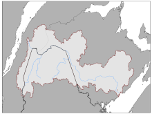
Lake of the Woods and Rainy River
The watershed forms the international boundary between Minnesota and Ontario, where waters flows some 600 km (372 miles) from Great Lakes basin divide, west through the chain lakes to Namakan Lake, Rainy Lake, and the Rainy River through Lake of the Woods, where at Kenora it enters the Lake Winnipeg basin ultimately flowing into Hudson’s Bay. Water Levels on the Lake of the Woods are controlled by the Canadian Lake of the Woods Board, except during times of extremely low and high water levels in which case authority lies with the International Lake of the Woods Board. The IJC’s International Joint Commission formed the International Rainy-Lake of the Woods Watershed Board to assist with binational coordination of water quality efforts for the entire boundary watershed and to coordinate the management of the water levels and flows on Rainy and Namakan lakes and the Rainy River.
Boards

Great Lakes - St. Lawrence River
The Great Lakes and St. Lawrence River hold 20 percent of the earth’s fresh surface water or 6 quadrillion gallons, cover a total area of 246,463 square kilometers or 95,160 square miles, and with the St. Lawrence River span 3,700 km (2,342 miles) or almost half of the North American continent. The watershed is one of the world’s most diverse with 3,500 species of plants and wildlife and more than 250 species of fish.
Water Levels Boards and Committee
- International Niagara Board of Control
- International Lake Ontario-St. Lawrence
- International Lake Superior Board of Control
- Great Lakes St. Lawrence River Adaptive Management Committee
Water Quality Boards

Lake Champlain-Richelieu River
The long, winding Lake Champlain sits primarily between New York and Vermont, and stretches north into Quebec, where it drains into the Richelieu River – and in turn, the St. Lawrence River. The lake is about 172 km (107 miles) long within the Lake Champlain Valley, getting water from several tributary rivers and from the Adirondack and Green Mountain ranges around it. In turn, around 250,000 people use the lake as a drinking water source from major cities such as Burlington, Vermont, and Plattsburgh, New York. The Richelieu River and Lake Champlain are also used for transporting tourists and locals via boats and for sport fishing, especially species like northern pike, bowfin, and largemouth bass. Because the system drains so much of the surrounding region, it does face water quality issues due to nutrient runoff, and periodically floods into the surrounding region. The IJC currently has a reference underway in the area to look at flooding in the Lake Champlain-Richelieu River system.
Studies
- International Lake Champlain-Richelieu River Study Board
- Nutrient Loading and Impacts in Lakes Champlain and Memphremagog

Lake Memphremagog
The 1,777 km2 (686 sq mile) Lake Memphremagog is located on the Quebec – Vermont border between Newport, in the United States and Magog, in Canada. Although the lake lies mostly in Quebec, most of the water supplies for the watershed come from Vermont. The IJC currently has a study looking at nutrient loading and its impacts on this lake and Lake Champlain currently.
Study
St. Croix River
The most easterly transboundary waterway, the 185 km (115 mile) St. Croix River runs along the border of Maine and New Brunswick before emptying into the Passamaquoddy estuary linked through the Bay of Fundy to the Atlantic Ocean. The river is heavily developed for hydropower generation, has been a major source of local drinking water, and has been a site for the lumber trade since at least European settlement began. People first came to the area around 6,000 years ago, however, enjoying the annual runs of fish like Atlantic salmon, alewives, shad and American eel. The dams have made it difficult for these species to make it up the river – as did a now-rescinded law in Maine trying to block alewives from the river – but efforts in recent years to improve fish passage have seen alewives and shad begin to rebuild their populations in the waterway. The St. Croix River Watershed Board reports to the IJC on compliance with water quality objectives and ensures that four privately owned dams are operated consistent with conditions set by IJC Orders of Approval.
Board
St. John River
The St. John River rises in separate streams in Maine and Quebec, coming together to form part of the international border between the two nations. It then turns southeastward into New Brunswick, where it flows into the Bay of Fundy. The 673 km (418 mile) river serves as a major hydropower source thanks to three dams along its course, though this led to a decline in migrating Atlantic salmon numbers and the loss of farmland. The St. John River is also the rare waterway that flows partially backwards when high tide on the Bay of Fundy comes in. The IJC held pollution studies on the river in the 1970s.