Record high Similkameen River flows cause Okanogan River to reverse direction at Zosel Dam
On November 15th, discharge of the Similkameen River began to increase rapidly. This was due in part to the landfall of a Category 5 atmospheric river causing heavy, sustained rainfall and rising temperatures resulting in additional runoff from snowmelt. A flood warning for the Similkameen River was issued by BC River Forecast Centre and National Weather Service on November 15th.
Discharge peaked at the USGS Similkameen River at Nighthawk gage at 26,900 cubic feet per second (cfs) (762 cubic meters per second (cms)) at 3:00 pm on November 16th. The previous historical maximum for the month of November during the 92-year record at this gage was 14,400 cfs (420 cms) on November 30th, 1995. The all-time historical maximum discharge of the Similkameen River at Nighthawk was 31,200 cfs (883 cms) on May 10th 2018 during the spring freshet.
The record high autumn discharge of the Similkameen River coupled with low Osoyoos Lake levels and minimal inflow of the Okanagan River into Osoyoos Lake, created a reversal of flow in the Okanogan River downstream of Osoyoos Lake. In the late evening on November 15th, the flow of the Okanogan River at Oroville reversed direction. At approximately 2:00 pm PST on November 16th, the river level downstream of Zosel Dam crested the dam’s spillway and began flowing up the channel towards Osoyoos Lake (Okanogan River at Oroville plot, with blue line dipping below zero). The upstream flow of the Similkameen River is apparent from upstream migration of the muddy Similkameen River water in comparison to clear Osoyoos Lake water. Aerial photography courtesy of Mary Davisson, Fisheries Biologist, Confederated Tribes of the Colville Reservation, shows that muddy Similkameen water reached Osoyoos Lake by 11:15 am PST on November 17th.
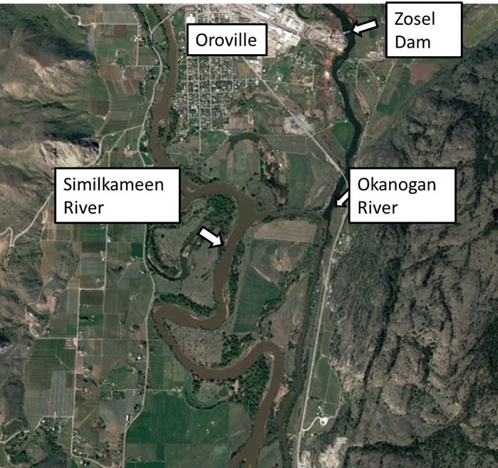
Location of Zosel Dam and the confluence of the Okanogan and Similkameen Rivers at Oroville, Washington.

Aerial photograph taken at 11:15 am PST on November 17, 2021, by Mary Davisson, Fisheries Biologist, Confederated Tribes of the Colville Reservation, of the outlet of Osoyoos Lake to the Okanogan River north of Oroville, Washington. Muddy water from the Similkameen River that flowed upstream into the Okanogan River contrasts with clear water in Osoyoos Lake.
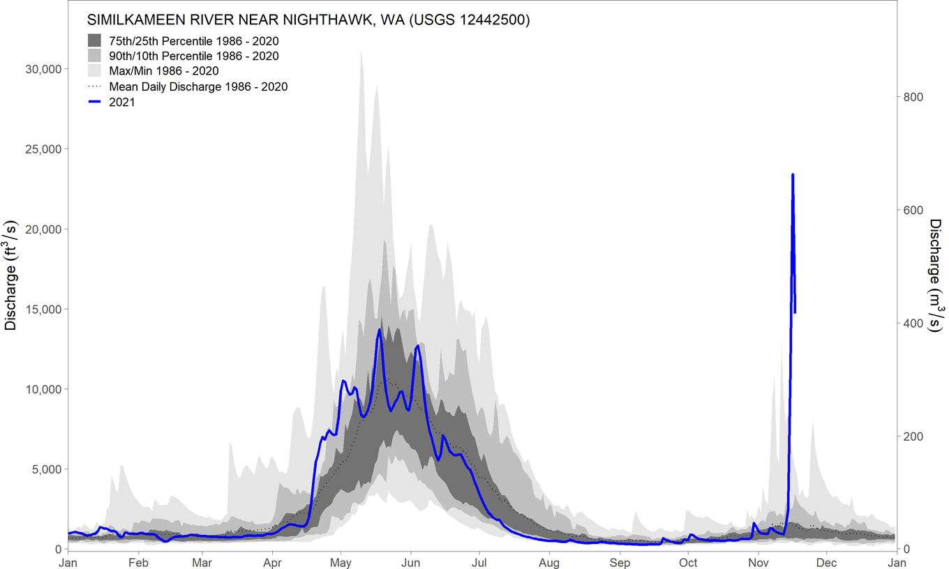
Figure 1 - Hydrograph of mean daily discharge of the Similkameen River near Nighthawk, Washington measured at USGS gage 12442500 between January 1, 2021, and November 17, 2021. Instantaneous discharge during the recent flood reached 26,900 cubic feet per second (cfs) (762 cubic meters per second (cms)) at 3:00 pm on November 16th.

Figure 2 - Hydrograph of mean daily discharge of the Okanogan River at Oroville, Washington measured at USGS gage 12439500 between January 1, 2021, and November 17, 2021. Negative discharge was measured during the recent Similkameen River flooding due to the high level of the Similkameen River relative to the level of Osoyoos Lake.

Figure 3 - Osoyoos Lake levels measured at USGS gage 12439000. Lake level increased due during recent flooding of the Similkameen River and resulting flow reversal of the Similkameen River.